 Fraunhofer Institute for Communication, Information Processing and Ergonomics FKIE
FKIE lokik project enters test phase of operation
The aim of the lokik project, whose name is a shortened form of the German for “local initial crisis management”, is to create an independent communication network and a flexible picture of the situations that arise in the acute phases of disasters. Scientists from the Fraunhofer Institute for Communication, Information Processing and Ergonomics FKIE have been working to achieve this since the night in 2021 when Germany’s Ahr Valley experienced a devastating flood. In spring 2022, the institute’s researchers officially presented their project for the first time in the building of the Winzer-Verein, a wine-grower’s association located in the Ahr Valley area of Mayschoß. A lot has happened since then — both in the flood-affected areas along the Ahr river and in the lokik project.


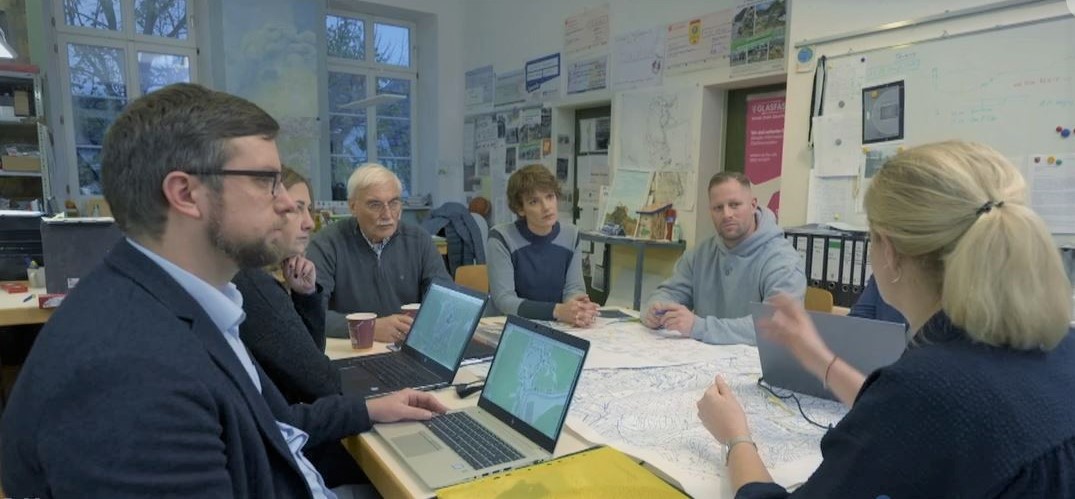
The small village of Birresdorf, situated in the municipality of Grafschaft, has about 930 inhabitants and 150 households. Along with Mayschoß and Remagen, it is one of the partners with whom FKIE has been working intensively on this project since its beginning. “The test phase is likely to start in May and will take place in Birresdorf,” says FKIE research group leader and project manager Arne Schwarze. “We want to sound out local people to find out how lokik might benefit them in their everyday lives.” The test installations in Mayschoß and Remagen are then set to be put in place before those involved in the project take a break for the summer.
Incorporating first-hand experiences of those affected by the flood into the lokik project has been of vital importance for the scientists from the very start. Many employees at the institute, whose headquarters are in Wachtberg in the same region, were also hit hard by the July 2021 disaster. Others were involved in the relief and clean-up work for weeks and months at a time. All the findings are being incorporated into the development of the project, which has now entered its second phase.
Schwarze describes the initial situation that many places in the Ahr Valley found themselves in: “No electricity, no grid, infrastructure destroyed, connections to the outside world simply cut off”. This situation is also the point at which the lokik solution, consisting of a hardware and a software component, is designed to kick in. Hardware plays a vital role in this scenario — especially in cases where communication networks fail, as they did in the Ahr disaster — as it makes it possible to establish a self-sufficient network through which end devices can access the digital lokik situation map. Computers and mobile communication components are stored in a safe place in the community. Then, in the event of a disaster, they can be put into operation independently of external technology with their own power supply — which can take the form of anything from a standard power bank to a power generator.
Software is based on a digital map
The software is based on a digital map that shows the infrastructure of a town or city. It can be accessed via a browser on a smartphone, tablet or computer. If disaster strikes, citizens can enter a situation report indicating damage or another issue, allowing the local crisis team to quickly obtain an overview and coordinate operations more effectively.
After the first round of feedback from the project partners in Birresdorf, Mayschoß and Remagen, at the end of 2022 the scientists expanded the lokik test system to include another component enabling local people to report not only issues, but also offers of support via the map. “The situation in the Ahr Valley showed that there was an enormous demand for things like drinking water, medicines, tools and vehicles,” Schwarze explains. These resources are likely to have been available somewhere in the area, but in many cases it was simply impossible to disseminate this information. Another addition has been the ability to allocate certain roles to map users. “Citizens and the local crisis team have different views of the map, for data protection reasons if nothing else,” Schwarze explains. “There is a third role that’s new: a kind of triager who checks the reported extent of damage and confirms it with the local crisis team, for example.”
During the test phase in the coming weeks, there will also be another round of feedback and more one-to-one interviews. Requirements identified during the interviews will then be sorted according to priority and incorporated into the system. In addition, lokik’s viability in practice will be put to the test during the summer as part of a large-scale exercise with Euskirchen Technical Relief Agency.
Positive responses to the project
The FKIE team has already received numerous positive responses to the project, which is set to run until September 2023. lokik has been a subject of discussion in not only TV reports on the channels ARD and WDR, but also at the conference of the Federal Office of Civil Protection and Disaster Assistance in Bonn and in several working groups of the North Rhine-Westphalia County Association. Some companies have already expressed their interest in the project as well.
Practical collaboration has been established with the German Armed Forces’ Center for Digitalization and Capability Development in the Cyber and Information Space: Starting in May, an interface with the Sitaware software — the basis for the German Armed Forces’ new command and control information system — will be developed for compatibility with lokik. Schwarze is keen to stress one particular point: “We don’t want to develop an isolated solution. With the appropriate interfaces, lokik can complement and supports other system, allowing it to deliver long-term benefits in the event of a disaster.”
Further information: www.fkie.fraunhofer.de/lokik
Last modified: